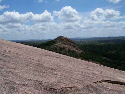
(click on the pictures for a larger view)

 Looking up from the base. About to start the climb up. Look real close and you can see two people standing on the top edge of the rock (you can't see the top of the rock from here because of its curve).
 Here is a closer look at the people.
 Enchanted Rock State Natural Area consists of 1643.5 acres on Big Sandy Creek, north of Fredericksburg, on the border between Gillespie and Llano Counties. It was acquired by warranty deed in 1978 by the Nature Conservancy of Texas, Inc., from the Moss family.
 It is beautiful pink granite.
 The state acquired it in 1984, added facilities, and reopened the park in March 1984, but humans have visited here for over 11,000 years. Enchanted Rock was designated a National Natural Landmark in 1970 and was placed on the National Register of Historic Places in 1984.
 The Rock is a huge, pink granite exfoliation dome, that rises 425 feet above ground, 1825 feet above sea level, and covers 640 acres. It is one of the largest batholiths (underground rock formation uncovered by erosion) in the United States.
 Tonkawa Indians believed ghost fires flickered at the top, and they heard weird creaking and groaning, which geologists now say resulted from the rock's heating by day and contracting in the cool night.
 A conquistador captured by the Tonkawa described how he escaped by losing himself in the rock area, giving rise to an Indian legend of a "pale man swallowed by a rock and reborn as one of their own." The Indians believed he wove enchantments on the area, but he explained that the rock wove the spells. "When I was swallowed by the rock, I joined the many spirits who enchant this place."
 The first well-documented explorations of this area did not begin until 1723 when the Spanish intensified their efforts to colonize Texas. During the mid-1700s, the Spaniards made several trips to the north and northwest of San Antonio, establishing a mission and presidio on the San Saba River and carrying out limited mining on Honey Creek near the Llano River.


